
Sustainability and Climate Change.
Urban Heat Islands
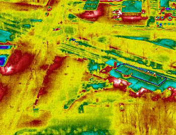
Urban Thermal Heat Mapping There are two types of heat, Atmospheric heat(weather) and surface heat. (a result of weather) Using drones equipped with thermal cameras, we will be focusing on the surface heat released from an object. The object's reflective heat is visually represented by a color palette and will help indicate if the surface is emitting heat or retaining heat. An asphalt road, for example, will retain heat and give off heat. On a hot day, the color of the road will show as red on a thermal camera. (given the particular color palette) Using a drone equipped with a thermal camera to capture information at the highest and lowest yearly diurnal cycles Multispectral can create comparative data that showcases thermal anomalies due to man-made structures or lack of environmental consideration such as tree equity.
Tree Equity
Multispectral will be using radiometric stitching to compose large-scale digital thermal maps of urban areas. These maps are referred to as "heat maps". The deliverable produced will showcase temperature differences within an urban heat island. There are several causes of surface temperature increase. The UAV will be capturing visual data on Paved and Impermeable Surfaces, Dark Surfaces, Lack of Vegetation. Increased Use of Air Conditioners, urban Canopy, and wind-blocking (caused by large man-made structures). Thermal maps will be one of two layers of the deliverable. The first layer is an RGB map that uses visible light to create a geo-referenced map. Environmental scientists can mitigate the thermal impact and can positively affect the amount of energy consumed. The heat map is an aid in tracking overall climate change over time. Digital maps can be shared on any platform of choice and combined with other information including, thermal ground mapping.
Conservation with consideration
Here at Multi Spectral Aerial Solutions, we customize our service delivery with communication as a priority to ensure our performance exceeds expectations. Using UAV technology flights can be done in an efficient manner that provides easy to read annotative information. Little if no physical impact is felt by the existing environment. Just like our Building envelope scans our environmental work is quiet, leaves no physical traces, and is efficient when compared to evasive methods such as walking on properties and possibly disturbing animal habitats and activity.